Concise overviews of recent MeritCorp projects will give you greater insight into how we transform even the most complex challenges into highly efficient solutions. Click here to view other project experience.
 |
McCook Reservoir
Chicago, Illinois
MeritCorp was selected to provide the construction staking for the
grout curtain around the McCook Reservoir that will be among the
deepest in North America. This is part of the second phase of Tunnel
and Reservoir Plan (TARP) including reservoir construction and tunnel connection. MeritCorp is working with Nicholson Construction Company
to carry out the construction of this challenging site located between
the Des Plaines River and the Illinois and Michigan Shipping Canal. The
McCook Reservoir will hold 7 billion gallons of waste water at a time. It
will serve as a storage basin during heavy rainfalls and increased usage
until it is treated. |
 |
LaFarge Kendall County Quarry
Lisbon, Illinois
MeritCorp was responsible for due diligence and engineering design of
286 acre quarry facility in the Village of Lisbon. MeritCorp coordinated
design with LaFarge’s land planning consultant and attorney. Scope of
due diligence services included wetland delineation/report and obtain
jurisdictional determination from the U.S. Army Corp of Engineers; Surveyed
Valley Run Creek (which transected the property) and established
100 year base flood elevation for creek; coordinated with the
Illinois Department of Natural Resources regarding endangered species
review. Scope of engineering services included design of offsite Joliet
Road improvements (2,390 linear feet.) and coordination with Kendall
County Highway Department to upgrade adjacent highway to 80,000
pound carrying capacity, storm water management design for site, sedimentation
basin design for quarry, soil erosion control design, on-site
access road design, coordinate bridge design over Valley Run Creek,
site grading design and earthwork analysis for berm/pond construction,
assist client in obtaining permits for construction and phase I mining
operations, represented client at public hearings. |
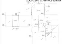 |
Vista Point
Plainfield, Illinois
MeritCorp completed a 7 parcel ALTA/ACSM Land Title Surveys totaling
more than 415 acres adjoining former Indian Land Boundaries. The accumulation
of properties compares the location of historical occupation
of farmlands and farmsteads to title lines, and their apparent gaps/
overlaps and encroachments. The identification of potential clouds in
title early in the due diligence process assists the client in costly revisions
and negotiations later in the development cycle. |
 |
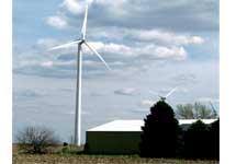
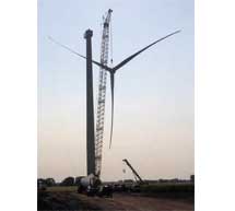
Ashtabula Energy Center
Ashtabula, North Dakota
MeritCorp is proud to have contributed to the success of the Ashtabula
Energy Center in North Dakota. The survey team provided the construction
staking using GPS technology. The collection system that was
laid out is responsible for servicing 131 wind turbines on the project
that generate 195 MegaWatts of electricity. The team worked alongside
MJ Electric and Blattner Energy exercising versatility and flexibility
with their scheduling enabling the construction crews to work
promptly and efficiently. As the project neared completion the MeritCorp
team gathered as-built data to ensure that the project was built
as it was designed. |
|
Located near the Town of Cape Vincent, New York, this project consists
of 65-70 wind turbines and associated improvements including:
private access roads, public road improvements, collection line and
turbine foundations. MeritCorp was responsible for establishing horizontal
and vertical control throughout the project area, preliminary
construction staking and evaluating the final turbine locations. |
|
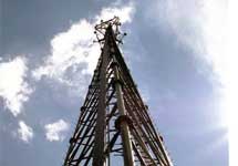
MeritCorp is responsible for research, data collection, field survey
work and preparing inventory maps for cellular towers throughout the
Midwest. Global Positioning technology is utilized to determine the
geodetic position of each tower. Remote sensing technology is utilized
to determine the height of each tower. Using this information, MeritCorp
is able to prepare tower positioning and height certifications to
meet rigorous Federal Aviation Agency and Federal Communications
Commissions standards. The resulting maps are utilized by the tower
owners to lease space for communications providers on each tower,
which maximizes the efficiency of space allocation and the necessity
for additional towers. |
 |
Meadow Lake Wind Farm
Indiana
The Meadow Lake Wind Farm spans Jasper, White and Benton Counties
in Indiana. The project has been broken up into six phases, of which
four are complete, and has the potential of generating 1,000 megawatts
of electricity. When complete, it will be one of the largest wind
farms in the world. MeritCorp contributed to the completion of Phases
II and IV. The team was responsible for the layout of various elements
of the proposed wind farm development including: private access
roads, laydown area, crane pads, wind turbine foundations, substation,
transmission lines and public road improvements. After construction
was completed, MeritCorp surveyed the site to verify the location of
the wind turbine generators, access roads and collection lines and provided
as-built information to the Client. |
|
MeritCorp was responsible for the land surveying for the Otter Creek
Wind Farm located in LaSalle County, Illinois. The project includes
approximately 117 parcels located within 24 sections of land and is
situated in two adjoining townships of LaSalle County. The project
consists of 100 wind turbine generators and associated improvements
including private access roads, collection lines and turbine foundations.
MeritCorp established a Global Positioning System (GPS) control
network, preliminary staking of the turbine locations, ALTA/Topo survey
and preparation of various exhibits for the design and permitting
purposes. |
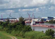 |
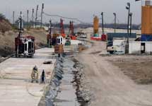
West Closure Complex (Gulf Intercoastal Waterway)
New Orleans, Louisiana
The Gulf Intercoastal Waterway West Closure Complex is a major component
for the Hurricane and Storm Damage Risk Reduction project
intended to minimize the risk of storm surges across the west bank
area near New Orleans, Louisiana. The complex consists of a drainage
pumping station with 16 vertical pipes that will be able to pump
20,000 cubic feet of water per second from the west shore of the Mississippi
River, keeping the surrounding areas from flooding.
MeritCorp’s team of experts was contracted by Gulf Intra Coastal Constructors
as a pre-construction necessity to establish a Static GPS Control
network for the complex as the basis for all future construction
staking tasks on the project. |